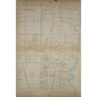
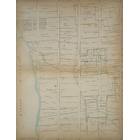
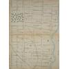
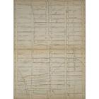
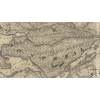
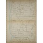
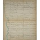
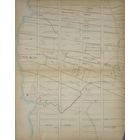
Map - Farm of Upper West Side in 1815  Year: 1815   Streets of New York City Random discovery !   📌

Click on the map to zoom more   Explore other maps of the same location but different year

magnifying glass - size


BANQ / Ville de Montréal - Source

Map added by anonnyous user

ID source: 1531818

ID local: 459

Number of object linked with that map : 3467

Year of the map: 1815

Legend Page 14: [Bounded by W. 94th Street, Eighth Avenue (Central Park West), W. 74th Street and Hudson River.], 1, 1, 1, 1, 1, 1, 1, 1, 1

Source Title: NYPL

Map's keywords:


186 Riverside Drive

535 West End Avenue

Richmond Apartments

The Collegiate School

San Remo Apartments

269 West 87th Street

Manchester House Apartments

15 West 81st Street, South Building [15 West 81st Street Buildings]

57 West 75th Street

697 West End Avenue

114 West 86th Street

Park Royal Hotel

98 Riverside Drive

514 West End Avenue

The Harrison

The Eldorado

Dutch Collegiate Church

Manhill Apartments

411 West End Avenue

411 West End Avenue

115 West 86th Street

Myron Arms Apartments

600 West End Avenue

Sherman Square Apartments

304 West 75th Street

220 West 93rd Street

Leader House Condominiums

Stephen Gaynor School And Ballet Hispanico

Holy Trinity Roman Catholic Church

710 West End Avenue

175 West 76th Street

Beresford Apartments

Hotel Orleans

The Packard

40 West 77th Street

Central Baptist Church of NYC

201 West 85th Street

Warwick Arms

Goddard Tower Apartments

600 Columbus Avenue

Montana Apartments

First Baptist Church

221 West 77th

589 Amsterdam Avenue

Glenn Gardens Apartments

West-Park Presbyterian Church

2230 Broadway

St. Volodymyr Ukrainian Orthodox Church of New York

Riverside Memorial Chapel

The Ansonia

Broadway United Church of Christ

Congregation Rodeph Sholom

250 81 ST

221 77 ST

206 77 ST

210 77 ST

67 87 ST

310 79 ST

100 89 ST

136 92 ST

315 84 ST

332 77 ST

210 82 ST

153 93 ST

302 77 ST

61 87 ST

35 87 ST

46 87 ST

320 77 ST

175 93 ST

314 77 ST

154 93 ST

201 90 ST

203 90 ST

205 82 ST

353 86 ST

215 76 ST

166 75 ST

266 95 ST

100 89 ST

52 87 ST

63 87 ST

156 92 ST

38 87 ST

53 87 ST

148 92 ST

336 77 ST

146 92 ST

533 AVE END

310 77 ST

30 87 ST

33 87 ST

68 87 ST

324 84 ST

201 82 ST

221 82 ST

349 86 ST

345 86 ST

307 79 ST

Add keywords

(Help us to describe the content of this map by writing the names of streets or other inscriptions on the map)


Add a comment or ask a question

There are not comment for this place now.


Progress 430 km2 Explored Keep your score !
Exploration Level 3
70  before next level
1850 - 1855 - 1860 - 1865 - 1870 - 1875 - 1880 - 1885 - 1890 - 1895 - 1900 - 1905 - 1910 - 1915 - 1920 - 1925 - 1930 - 1935 - 1940 - 1945 - 1950 - 1955 - 1960 - 1965 - 1970 - 1975 - 1980 - 1985 - 1990 - 1995 - 2000 - 2005 - 2010 - 2015 - 2020 -