Carte - 1885 plate 14  Année: 1885   Rues de New York City Découverte aléatoire!   📌

Cliquez sur la carte pour augmenter le zoom   Explorer d'autre carte de la même localisation

Loupe - Grandeur


BANQ / Ville de Montréal - Source

Carte ajoutée par un usager anonyme

ID source:

ID local: 293

Nombre d'objets liés avec cette carte: 1512

Année de la carte: 1885
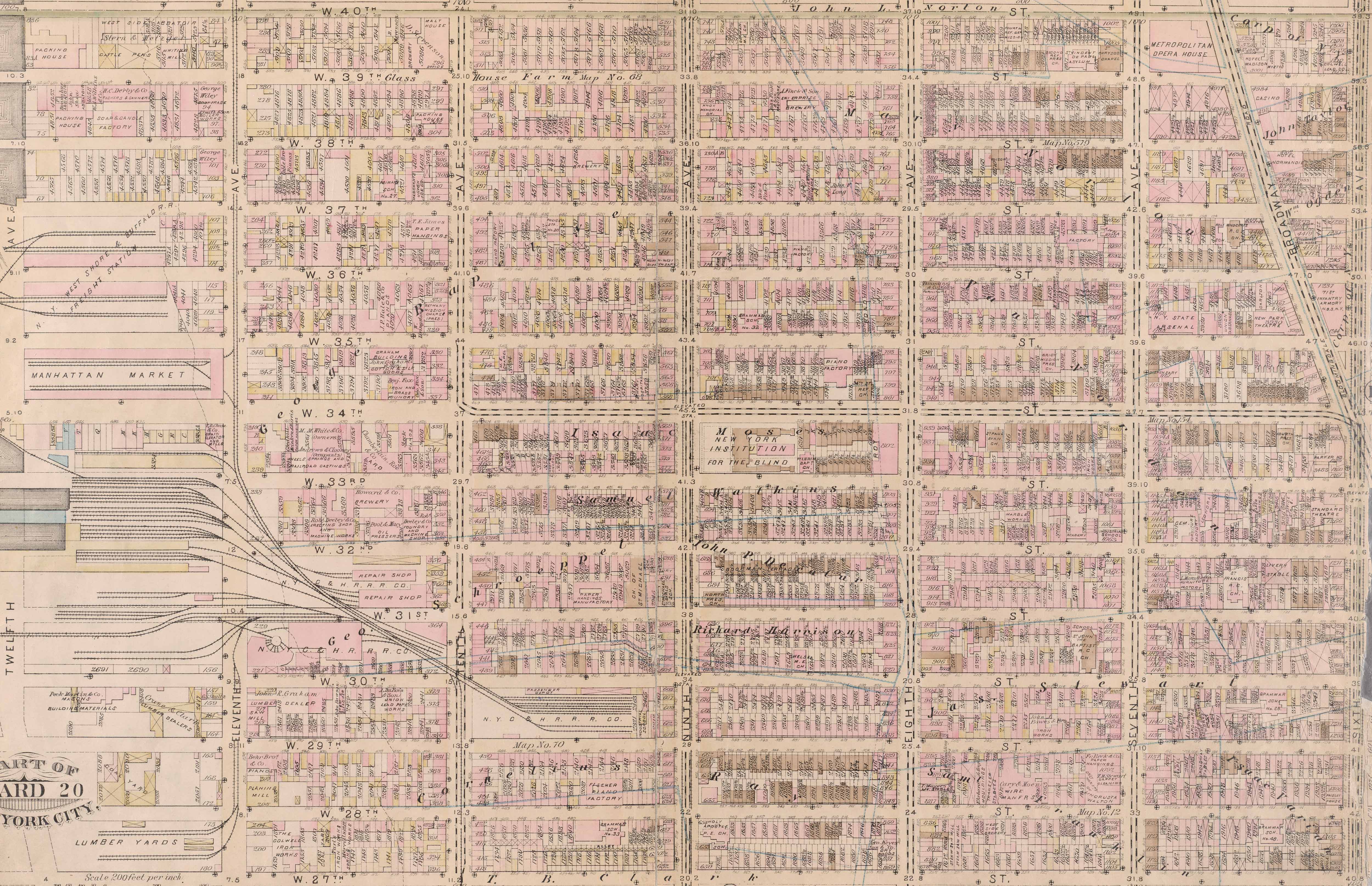
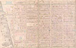
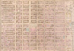
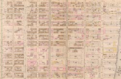
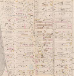
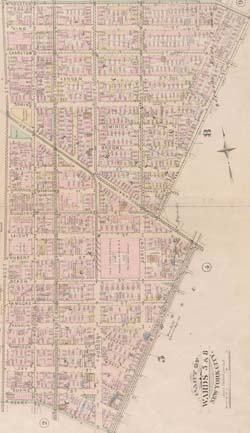
Légende Plate 14: Bounded by W. 40th Street, Sixth Avenue, W. 27th Street and Twelfth Avenue., 1, 1, 1, 1, 1, 1, 1, 1, 1

Mots clés de la carte:


444 Tenth Avenue

St John the Baptist Rc Church

422 11th Avenue

450 Eleventh Avenue

21 Penn Plaza

Kheel Tower

Garment Center South Building

Candlewood Suites New York City- Times Square

323 10th Avenue

Marriott Courtyard New York Manhattan/Times Square South

Madison Square Garden

310 West 40th Street

66 Hudson Boulevard

Chelsea Place

Church of the Holy Apostles

440 West 34th Street

1400 Broadway

Fashion Institute of Technology Dorms

515 W 29th Street

345 7th Avenue

Emerald Green

370 West 35th Street

3 Hudson Boulevard

242 West 30th Street

30 Hudson Yards

342 West 39th Street

Caxton Building

Tower 39

Distrikt Hotel

363 7th Avenue

525 Eighth Avenue

430 West 34th Street

knickerbocker Theatre

129 West 29th Street

462 7th Avenue

515 West 36th Street

NYPD old 23rd Precinct on West 30th Street

Kratter Building

The Pestana Hotel

St. Vincent de Paul Orphan Asylum

USPS Morgan General Mail Facility

Penn Station South Houses IV [Penn Station South Houses]

DoubleTree Hotel New York City - Chelsea

525 7th Avenue

241 West 28th Street

Homewood Suites by Hilton New York/Midtown Manhattan Times Square-South

Church of St. Francis of Assisi

50 Hudson Yards

267 West 34th

Herald Square

249 West 29th Street

Morgan General Mail Facility

211 West 29th Street

601 W 29th St

Bricken Casino Building

134 West 29th Street

World Apparel Center

Hotel Normandie

Maxine Elliott Theatre

71st Street Infantry Armory N. G. S. N. Y.

1 HERALD SQUARE

4 HERALD SQUARE

7 BRYANT PARK

5 BRYANT PARK

50 HUDSON YARDS

1 HUDSON YARDS

533 30 ST

10 HUDSON YARDS

501 30 ST

505 30 ST

515 30 ST

517 30 ST

525 30 ST

531 30 ST

535 30 ST

541 30 ST

242 27 ST

338 36 ST

1039 OF THE AMERICAS

337 36 ST

553 30 ST

545 30 ST

532 33 ST

341 9 AVE

351 38 ST

515 36 ST

111 28 ST

256 27 ST

520 37 ST

303 10 AVE

309 10 AVE

124 30 ST

1021 OF THE AMERICAS

1029 OF THE AMERICAS

1029 OF THE AMERICAS

296 9 AVE

227 27 ST

350 39 ST

323 26 ST

Ajouter des mots clés

(Aidez nous à décrir le contenu de cette carte en y écrivant les noms de rues ou autres inscrit de la carte)


Ajouter un commentaire, poser une question à tous

Il n'y a pas de commentaire pour le moment


Progrès: 10 km2 exploré
Niveau explorateur 1
90  avant le prochain niveau
1850 - 1855 - 1860 - 1865 - 1870 - 1875 - 1880 - 1885 - 1890 - 1895 - 1900 - 1905 - 1910 - 1915 - 1920 - 1925 - 1930 - 1935 - 1940 - 1945 - 1950 - 1955 - 1960 - 1965 - 1970 - 1975 - 1980 - 1985 - 1990 - 1995 - 2000 - 2005 - 2010 - 2015 - 2020 -