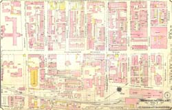
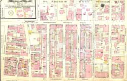
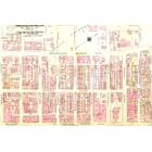
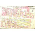
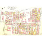
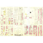
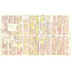
Map - Centre-Ville avant la Place Ville-Marie - 1912 plate 15 Year: 1912 Streets of Montréal Random discovery ! 📌
Click on the map to zoom more ⚲ Explore other maps of the same location but different year
magnifying glass - size

BANQ / Ville de Montréal - Source
Map added by anonnyous user
ID source:
ID local: 2
Number of object linked with that map : 128
Year of the map: 1912
Legend Peel / Saint-Alexandre entre Sainte-Catherine et La Gauchetière, 1, 1, 1, 1, 1, 1, 1, 1, 1, 1, 1, 1, 1, 1, 1, 1, 1, 1, 1, 1, 1, 1, 1, 1, 1, 1, 1, 1, 1, 1, 1, 1, 1, 1, 1, 1, 1, 1, 1, 1, 1, 1, 1, 1, 1, 1, 1, 1, 1, 1, 1, 1, 1, 1, 1, 1, 1, 1, 1, 1, 1, 1, 1, 1, 1, 1, 1, 1, 1, 1, 1, 1, 1, 1, 1, 1, 1, 1, 1, 1, 1, 1, 1, 1, 1, 1, 1, 1, 1, 1, 1, 1, 1, 1, 1, 1, 1, 1, 1, 1, 1, 1, 1, 1, 1, 1, 1, 1, 1, 1, 1, 1, 1, 1, 1, 1, 1, 1, 1, 1, 1, 1, 1, 1, 1, 1, 1, 1, 1, 1, 1, 1, 1, 1, 1, 1, 1, 1, 1, 1, 1, 1, 1, 1, 1, 1, 1, 1, 1, 1, 1, 1, 1, 1, 1, 1, 1, 1, 1, 1, 1, 1, 1, 1, 1, 1, 1, 1, 1, 1, 1, 1, 1, 1, 1, 1, 1, 1, 1, 1, 1, 1, 1, 1, 1, 1, 1, 1, 1, 1
Source Title: Atlas of the City of Montreal and vicinity - Chas. E. Goad Co. 0000174399 015
Map's keywords: Thistle Terrace Andrews Home St Patrick School St Bridget Homes Beaver Hall Square Hanover Street Rue Brunswick Rue Geneviève joliette soeurs de la providence
Add keywords
(Help us to describe the content of this map by writing the names of streets or other inscriptions on the map)
Map limits
See the limits of all the maps of the same year
( Réserver aux membres)

Add a comment or ask a question