Map - 3216546_0103 Year: 1939 Streets of Montréal Random discovery ! 📌
Click on the map to zoom more ⚲ Explore other maps of the same location but different year
magnifying glass - size
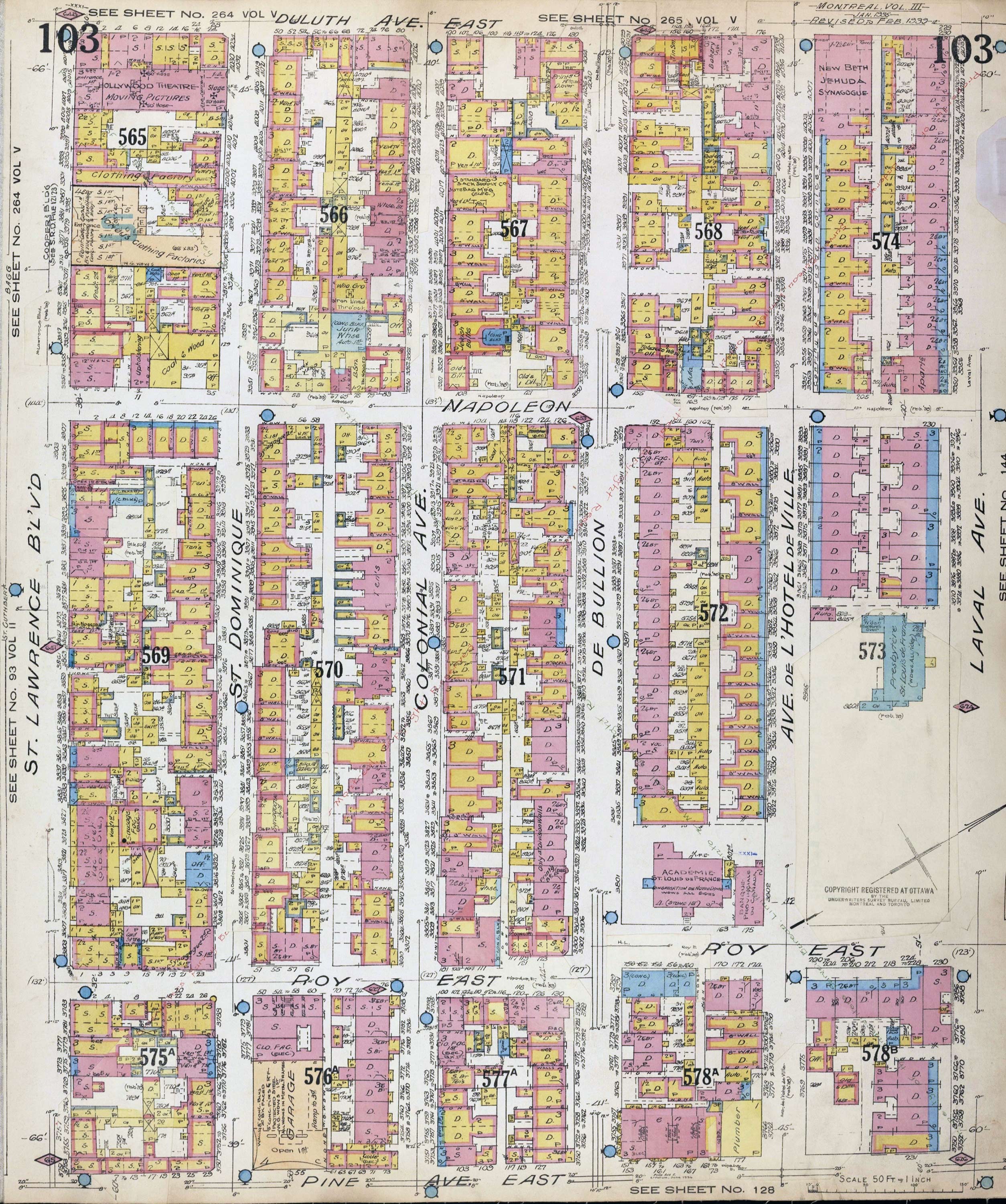
BANQ / Ville de Montréal - Source
Map added by anonnyous user
ID source:
ID local: 120
Number of object linked with that map : 362
Year of the map: 1939
Legend , 1, 1, 1, 1, 1, 1, 1, 1, 1, 1, 1, 1, 1, 1, 1, 1, 1, 1, 1, 1, 1, 1, 1, 1, 1, 1, 1, 1, 1, 1, 1, 1, 1, 1, 1, 1, 1, 1, 1, 1, 1, 1, 1, 1, 1, 1, 1, 1, 1, 1, 1, 1, 1, 1, 1, 1, 1, 1, 1, 1, 1, 1, 1, 1, 1, 1, 1, 1, 1, 1, 1, 1, 1, 1, 1, 1, 1, 1, 1, 1, 1, 1, 1, 1, 1, 1, 1, 1, 1, 1, 1, 1, 1, 1, 1, 1, 1, 1, 1, 1, 1, 1, 1, 1, 1, 1, 1, 1, 1, 1, 1, 1, 1, 1, 1, 1, 1, 1, 1, 1, 1, 1, 1, 1, 1, 1, 1, 1, 1, 1, 1, 1, 1, 1, 1, 1, 1, 1, 1, 1, 1, 1, 1, 1, 1, 1, 1, 1, 1, 1, 1, 1, 1, 1, 1, 1, 1, 1, 1, 1, 1, 1, 1, 1, 1, 1, 1, 1, 1, 1, 1, 1, 1, 1, 1, 1, 1, 1, 1, 1, 1, 1, 1, 1, 1, 1, 1, 1, 1, 1, 1, 1, 1, 1
Map's keywords:
Add keywords
(Help us to describe the content of this map by writing the names of streets or other inscriptions on the map)
Legende?
Bonjour, y-a-t'il une legende pour le plan? Par exemple, les couleurs jaune, bleu et rose designent quoi? Les lettres D et S, meme chose? Mon pere habitait juste au coin de Bullion et Roy, nord-ouest.
Merci, Heather
Map limits
See the limits of all the maps of the same year
( Réserver aux membres)
Add a comment or ask a question