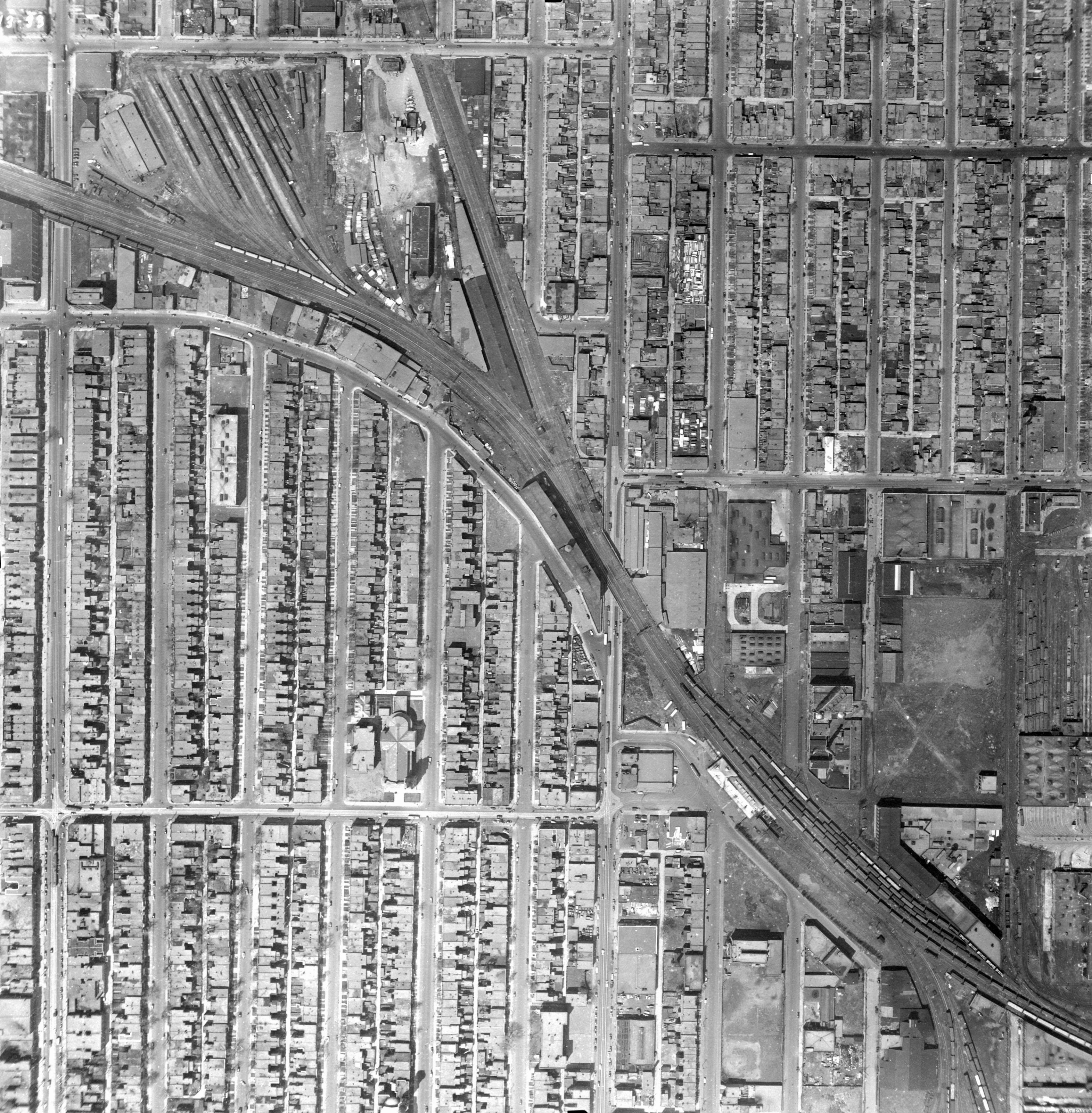
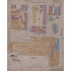
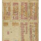
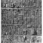
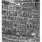
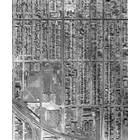
Map - Mile End - Vue aérienne Montréal 1947-1949 Year: 1949 Streets of Montréal Random discovery ! 📌
Add by : Alain_Histoire ![]()
Click on the map to zoom more ⚲ Explore other maps of the same location but different year
magnifying glass - size
BANQ / Ville de Montréal - Source
Map added by anonnyous user
ID source:
ID local: 10
Number of object linked with that map : 1466
Year of the map: 1949
Legend , 1, 1, 1, 1, 1, 1, 1, 1, 1, 1, 1, 1, 1, 1, 1, 1, 1, 1, 1, 1, 1, 1, 1, 1, 1, 1, 1, 1, 1, 1, 1, 1, 1, 1, 1, 1, 1, 1, 1, 1, 1, 1, 1, 1, 1, 1, 1, 1, 1, 1, 1, 1, 1, 1, 1, 1, 1, 1, 1, 1, 1, 1, 1, 1, 1, 1, 1, 1, 1, 1, 1, 1, 1, 1, 1, 1, 1, 1, 1, 1, 1, 1, 1, 1, 1, 1, 1, 1, 1, 1, 1, 1, 1, 1, 1, 1, 1, 1, 1, 1, 1, 1, 1, 1, 1, 1, 1, 1, 1, 1, 1, 1, 1, 1, 1, 1, 1, 1, 1, 1, 1, 1, 1, 1, 1, 1, 1, 1, 1, 1, 1, 1, 1, 1, 1, 1, 1, 1, https://histograd.com/, histograd.com, 1, xfs.bxss.me, 1, 1, 1, 1, 1, 1, 1, 1, 1, 1, 1, 1, 1, 1, 1, 1, 1, 1, 1, 1, 1, 1, 1, 1, 1, 1, 1, 1, 1, 1, 1, 1, 1, 1, 1, 1, 1, 1, 1, 1, 1, 1, 1, 1, 1, 1, 1, 1, 1, 1, 1, 1, 1, 1, 1, 1, 1, 1, 1, 1, 1, 1, 1, 1, 1, 1, 1, 1, 1, 1, 1, 1, 1, -1 OR 2+150-150-1=0+0+0+1 -- , -1 OR 3+150-150-1=0+0+0+1 -- , -1 OR 3*2<(0+5+150-150) -- , -1 OR 3*2>(0+5+150-150) -- , -1 OR 2+197-197-1=0+0+0+1, -1 OR 3+197-197-1=0+0+0+1, -1 OR 3*2<(0+5+197-197), -1 OR 3*2>(0+5+197-197), -1' OR 2+386-386-1=0+0+0+1 -- , -1' OR 3+386-386-1=0+0+0+1 -- , -1' OR 3*2<(0+5+386-386) -- , -1' OR 3*2>(0+5+386-386) -- , -1' OR 2+898-898-1=0+0+0+1 or 'qJ6iAAPH'=', -1' OR 3+898-898-1=0+0+0+1 or 'qJ6iAAPH'=', -1' OR 3*2<(0+5+898-898) or 'qJ6iAAPH'=', -1' OR 3*2>(0+5+898-898) or 'qJ6iAAPH'=', -1" OR 2+921-921-1=0+0+0+1 -- , 1, -1" OR 3+921-921-1=0+0+0+1 -- , -1" OR 3*2<(0+5+921-921) -- , -1" OR 3*2>(0+5+921-921) -- , 1*if(now()=sysdate(),sleep(15),0), 10'XOR(1*if(now()=sysdate(),sleep(15),0))XOR'Z, 10"XOR(1*if(now()=sysdate(),sleep(15),0))XOR"Z, (select(0)from(select(sleep(15)))v)/*'+(select(0)from(select(sleep(15)))v)+'"+(select(0)from(select(sleep(15)))v)+"*/, (select(0)from(select(sleep(16.713)))v)/*'+(select(0)from(select(sleep(16.713)))v)+'"+(select(0)from(select(sleep(16.713)))v)+"*/, 1-1; waitfor delay '0:0:15' -- , 1-1); waitfor delay '0:0:15' -- , 1, 1, 1-1 waitfor delay '0:0:15' -- , 1, 1, 11TxrBnXz'; waitfor delay '0:0:15' -- , 1, 1-1 OR 65=(SELECT 65 FROM PG_SLEEP(15))--, 1, 1, 1, 1, 1, 1, 1, 1, 1, 1, 1, 1, 1, 1, 1, 1, 1-1) OR 543=(SELECT 543 FROM PG_SLEEP(15))--, 1, https://histograd.com/, histograd.com, xfs.bxss.me, 1, 1-1)) OR 132=(SELECT 132 FROM PG_SLEEP(15))--, 1, -1 OR 2+767-767-1=0+0+0+1 -- , -1 OR 3+767-767-1=0+0+0+1 -- , -1 OR 3*2<(0+5+767-767) -- , -1 OR 3*2>(0+5+767-767) -- , -1 OR 2+710-710-1=0+0+0+1, -1 OR 3+710-710-1=0+0+0+1, -1 OR 3*2<(0+5+710-710), -1 OR 3*2>(0+5+710-710), -1' OR 2+22-22-1=0+0+0+1 -- , 1oMGeoECC' OR 624=(SELECT 624 FROM PG_SLEEP(15))--, -1' OR 3+22-22-1=0+0+0+1 -- , -1' OR 3*2<(0+5+22-22) -- , -1' OR 3*2>(0+5+22-22) -- , -1' OR 2+414-414-1=0+0+0+1 or 'zv8FVi4H'=', -1' OR 3+414-414-1=0+0+0+1 or 'zv8FVi4H'=', -1' OR 3*2<(0+5+414-414) or 'zv8FVi4H'=', -1' OR 3*2>(0+5+414-414) or 'zv8FVi4H'=', -1" OR 2+112-112-1=0+0+0+1 -- , -1" OR 3+112-112-1=0+0+0+1 -- , -1" OR 3*2<(0+5+112-112) -- , -1" OR 3*2>(0+5+112-112) -- , 1cBpQt4Ho' OR 704=(SELECT 704 FROM PG_SLEEP(15))--, 1*if(now()=sysdate(),sleep(15),0), 1, 1, 1EsqhIpWe') OR 51=(SELECT 51 FROM PG_SLEEP(15))--, 10'XOR(1*if(now()=sysdate(),sleep(15),0))XOR'Z, 1NVRxfTpL')) OR 952=(SELECT 952 FROM PG_SLEEP(15))--, 10"XOR(1*if(now()=sysdate(),sleep(15),0))XOR"Z, 1*DBMS_PIPE.RECEIVE_MESSAGE(CHR(99)||CHR(99)||CHR(99),15), (select(0)from(select(sleep(15)))v)/*'+(select(0)from(select(sleep(15)))v)+'"+(select(0)from(select(sleep(15)))v)+"*/, 1'||DBMS_PIPE.RECEIVE_MESSAGE(CHR(98)||CHR(98)||CHR(98),15)||', 1, 1'", @@4DmuF, 1-1; waitfor delay '0:0:15' -- , 1-1); waitfor delay '0:0:15' -- , 1-1 waitfor delay '0:0:15' -- , 1MCvOT46Q'; waitfor delay '0:0:15' -- , 1-1 OR 809=(SELECT 809 FROM PG_SLEEP(15))--, 1-1) OR 323=(SELECT 323 FROM PG_SLEEP(15))--, 1-1)) OR 653=(SELECT 653 FROM PG_SLEEP(15))--, 1Y7DYSrrl' OR 743=(SELECT 743 FROM PG_SLEEP(15))--, 1y8C1K1Nh') OR 792=(SELECT 792 FROM PG_SLEEP(15))--, 1mJQumiC8')) OR 173=(SELECT 173 FROM PG_SLEEP(15))--, 1*DBMS_PIPE.RECEIVE_MESSAGE(CHR(99)||CHR(99)||CHR(99),15), 1'||DBMS_PIPE.RECEIVE_MESSAGE(CHR(98)||CHR(98)||CHR(98),15)||', 1, 1'", @@k6cTq, 1, 1, 1, 1, 1, 1, 1, 1, 1, 1, 1, 1, 1, 1, 1, 1, 1, 1, 1, 1, 1, 1, 1, 1, 1, 1, 1, 1, 1, 1, 1, 1, 1, 1, 1, 1, 1, 1, 1, 1, 1
Source Title: Archive de la Ville de Montréal VM97-3_7P13-33
Map's keywords: Canadien-Pacific Mile-End Rue Bernard 1949 Édifice Catelli Église St-Georges Brasserie Frontenac 6356 casgrain outremont eglise st georges Rue Beaubien Ouest Chemin de Fer CP Boulevard Saint-Laurent Rue Bellechasse Ancienne gare du Mile-End 6286 Mentana eglise Saint Georges 412 rue bernard avenue laval maisonneuve 5504 rue Saint-Denis Restaurant Richard rue Boyer Mile end Rue Bernard et saint laurent Van horne warehouse Saint Georges B Bernard et saint Urbain B Bernard et saint Urbain B Bernard et saint Urbain https://histograd.com/ histograd.com xfs.bxss.me -1 OR 2+357-357-1=0+0+0+1 -- -1 OR 3+357-357-1=0+0+0+1 -- -1 OR 3*2<(0+5+357-357) -- -1 OR 3*2>(0+5+357-357) -- -1 OR 2+353-353-1=0+0+0+1 -1 OR 3+353-353-1=0+0+0+1 -1 OR 3*2<(0+5+353-353) -1 OR 3*2>(0+5+353-353) -1' OR 2+902-902-1=0+0+0+1 -- -1' OR 3+902-902-1=0+0+0+1 -- -1' OR 3*2<(0+5+902-902) -- -1' OR 3*2>(0+5+902-902) -- -1' OR 2+634-634-1=0+0+0+1 or 'YqLPZCpl'=' -1' OR 3+634-634-1=0+0+0+1 or 'YqLPZCpl'=' -1' OR 3*2<(0+5+634-634) or 'YqLPZCpl'=' -1' OR 3*2>(0+5+634-634) or 'YqLPZCpl'=' -1" OR 2+585-585-1=0+0+0+1 -- -1" OR 3+585-585-1=0+0+0+1 -- -1" OR 3*2<(0+5+585-585) -- -1" OR 3*2>(0+5+585-585) -- 1*if(now()=sysdate() sleep(15) 0) 10'XOR(1*if(now()=sysdate() sleep(15) 0))XOR'Z 10"XOR(1*if(now()=sysdate() sleep(15) 0))XOR"Z (select(0)from(select(sleep(15)))v)/*'+(select(0)from(select(sleep(15)))v)+'"+(select(0)from(select(sleep(15)))v)+"*/ 1-1; waitfor delay '0:0:15' -- 1-1); waitfor delay '0:0:15' -- 1-1 waitfor delay '0:0:15' -- 1i4bdDkUW'; waitfor delay '0:0:15' -- 1V8WVecrA'; waitfor delay '0:0:3.76' -- 1i1ccDMhH'; waitfor delay '0:0:7.52' -- 1-1 OR 895=(SELECT 895 FROM PG_SLEEP(15))-- 1-1) OR 958=(SELECT 958 FROM PG_SLEEP(15))-- 1-1)) OR 508=(SELECT 508 FROM PG_SLEEP(15))-- 1CSSvds7w' OR 883=(SELECT 883 FROM PG_SLEEP(15))-- 1GRLDkcxg') OR 35=(SELECT 35 FROM PG_SLEEP(15))-- 1dPq5UCob')) OR 597=(SELECT 597 FROM PG_SLEEP(15))-- 1*DBMS_PIPE.RECEIVE_MESSAGE(CHR(99)||CHR(99)||CHR(99) 15) 1'" @@UxcK4 https://histograd.com/ histograd.com xfs.bxss.me -1 OR 2+279-279-1=0+0+0+1 -- -1 OR 3+279-279-1=0+0+0+1 -- -1 OR 3*2<(0+5+279-279) -- -1 OR 3*2>(0+5+279-279) -- -1 OR 2+161-161-1=0+0+0+1 -1 OR 3+161-161-1=0+0+0+1 -1 OR 3*2<(0+5+161-161) -1 OR 3*2>(0+5+161-161) -1' OR 2+648-648-1=0+0+0+1 -- -1' OR 3+648-648-1=0+0+0+1 -- -1' OR 3*2<(0+5+648-648) -- -1' OR 3*2>(0+5+648-648) -- -1' OR 2+906-906-1=0+0+0+1 or 'pBOqv1Ev'=' -1' OR 3+906-906-1=0+0+0+1 or 'pBOqv1Ev'=' -1' OR 3*2<(0+5+906-906) or 'pBOqv1Ev'=' -1' OR 3*2>(0+5+906-906) or 'pBOqv1Ev'=' -1" OR 2+612-612-1=0+0+0+1 -- -1" OR 3+612-612-1=0+0+0+1 -- -1" OR 3*2<(0+5+612-612) -- -1" OR 3*2>(0+5+612-612) -- 1*if(now()=sysdate() sleep(15) 0) (select(0)from(select(sleep(15)))v)/*'+(select(0)from(select(sleep(15)))v)+'"+(select(0)from(select(sleep(15)))v)+"*/ (select(0)from(select(sleep(15)))v)/*'+(select(0)from(select(sleep(15)))v)+'"+(select(0)from(select(sleep(15)))v)+"*/ 1-1; waitfor delay '0:0:15' -- 1-1); waitfor delay '0:0:15' -- 1-1 waitfor delay '0:0:15' -- 1XJXXKqfI'; waitfor delay '0:0:15' -- 1-1 OR 194=(SELECT 194 FROM PG_SLEEP(15))-- 1-1) OR 156=(SELECT 156 FROM PG_SLEEP(15))-- 1-1)) OR 13=(SELECT 13 FROM PG_SLEEP(15))-- 1QzvGuw91' OR 913=(SELECT 913 FROM PG_SLEEP(15))-- 19CJI2oVX') OR 245=(SELECT 245 FROM PG_SLEEP(15))-- villa m 6132 waverly outremont
Add keywords
(Help us to describe the content of this map by writing the names of streets or other inscriptions on the map)
Map limits
See the limits of all the maps of the same year
( Réserver aux membres)
Maps from same year


Add a comment or ask a question