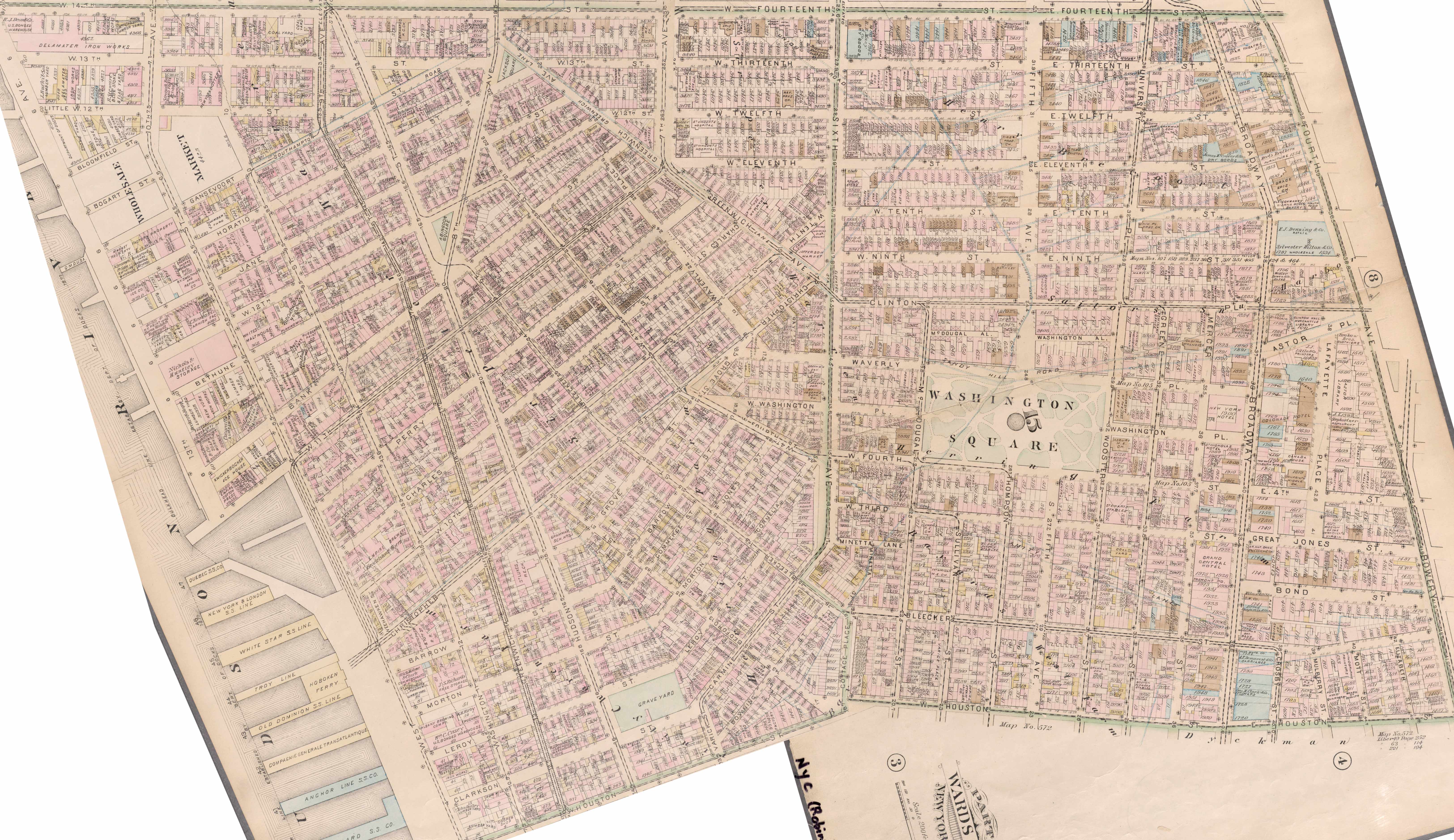
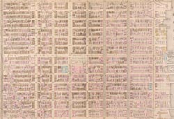
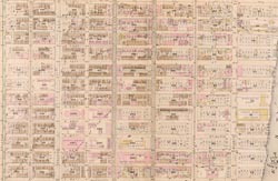
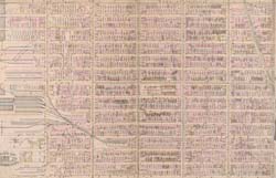
Map - West Village in 1885  Year: 1885   Streets of New York City Random discovery !   📌

Click on the map to zoom more   Explore other maps of the same location but different year

magnifying glass - size


BANQ / Ville de Montréal - Source

Map added by anonnyous user

ID source: 1512154

ID local: 437

Number of object linked with that map : 5563

Year of the map: 1885

Legend , 1, 1, 1, 1, 1

Source Title: NYPL

Map's keywords: 392 bleecker 392 bleecker 10th Street 13th street


Church of the Ascension, Episcopal

Cambridge House Apartments

366 West 11th Street Condominiums

Salmagundi Club

51 Astor Place

109 Prince Street

Judson Memorial Church

Grace Church Neighborhood House

827 Broadway

Brown Building (Asch Building)

299 West 12th Condominiums

United States Federal Building

The Three Sixty Condominium

Grace Church

Standard Hotel

21 Astor Place

Hyatt Union Square New York

Samuel Tredwell Skidmore House

Warren Weaver Hall [New York University]

Hilary Gardens

The Church of Saint Luke in the Fields

100 Barrow Street

70 East 12th Street

99 University Place

21 East 12th Street

165 Mercer Street

Solar Carve Tower

One Fifth Avenue

37 Washington Square West

University Place Presbyterian Church

The Beauclaire

Astor Library (Hebrew Immigrant Aid Society Building)

Judson Hall

Georgetown Plaza Apartments

40 10th Avenue

Lenox Hill HealthPlex

The Cooper Union

2 5th Avenue

837 Washington Street

Holly Chambers Apartments

Brown Building, NYU

348 Lafayette Street

La Grange Terrace (Colonnade Row)

15 Charles Street

NYU Alumni Hall

Bible House

One Union Square South

Guggenheimer Building

285 Mercer Street

88 University Place

Old Singer Building

1 University Place

14 Fifth Avenue

Puck Building

DVF Headquarters

3 SHERIDAN SQUARE

12 SHERIDAN SQUARE

12 SHERIDAN SQUARE

2 SHERIDAN SQUARE

1 SHERIDAN SQUARE

10 SHERIDAN SQUARE

13 SHERIDAN SQUARE

412 OF THE AMERICAS

78 ST MORTON

625 ST GREENWICH

487 ST HUDSON

668 ST GREENWICH

10 ST BEDFORD

52 14 ST

52 13 ST

42 ST KING

17 13 ST

165 ST CHARLES

193 ST BLEECKER

111 ST LEROY

115 ST LEROY

117 ST LEROY

119 ST LEROY

121 ST LEROY

621 ST GREENWICH

166 ST BANK

451 BROADWAY

588 BROADWAY

342 14 ST

13 12 ST

13 12 ST

15 12 ST

59 4 ST

410 13 ST

273 ST BLEECKER

263 ST BLEECKER

281 OF THE AMERICAS

259 ST BLEECKER

93 ST MAC DOUGAL

195 ST BLEECKER

29 7 AVE

136 ST HOUSTON

453 BROADWAY

61 4 ST

Add keywords

(Help us to describe the content of this map by writing the names of streets or other inscriptions on the map)


Add a comment or ask a question

There are not comment for this place now.


Progress 10 km2 Explored
Exploration Level 1
90  before next level
1850 - 1855 - 1860 - 1865 - 1870 - 1875 - 1880 - 1885 - 1890 - 1895 - 1900 - 1905 - 1910 - 1915 - 1920 - 1925 - 1930 - 1935 - 1940 - 1945 - 1950 - 1955 - 1960 - 1965 - 1970 - 1975 - 1980 - 1985 - 1990 - 1995 - 2000 - 2005 - 2010 - 2015 - 2020 -